
Wetlands occur extensively across the Nile Basin, supporting livelihoods of millions of people and providing a unique ecosystem, rich habitat and breeding grounds for fish, amphibians and migrating birds.
Unfortunately, and despite such vital functions, wetlands are declining the world over. According to the Ramsar Global Wetlands Outlook (2018), 35% of the world’s wetlands were lost between 1970-2015, resulting in a staggering loss of 81% of inland wetland species populations. The loss rate is rising, driven by human population increase, urbanization, and changes to land and water use and agriculture. The remaining wetlands are under serious threat from pollution, unsustainable use, invasive species, disrupted flows from dams, and sediment dumping from deforestation and soil erosion.
Wetlands International is contributing towards addressing these challenges by implementing “ Wetlands Across Borders” project that involves: undertaking landscape analyses, participatory wetlands assessments and development of transboundary wetland management plans that simultaneously incentivize stakeholders to conserve the wetlands by promoting sustainable livelihoods. The scope of the project covers the following three transboundary wetlands: Sango Bay – Minziro, Semliki Delta and Sio-Siteko.
Sango Bay – Minziro Wetland landscape is located west of Lake Victoria and lies at the boundary between Uganda and Tanzania. The Sango Bay – Minziro Wetland lies between latitude 0.51 – 1.30 ° S and longitude 31.38 – 31.88 ° E with an approximate area of 3,000 square kilometres (1,244 in Tanzania and 1,746 in Uganda).
Within Uganda, the wetland landscape is concentrated in the Kyotera and Kakuuto Counties in Kyotera District. It is part of the Sango Bay Musambwa Island – Kagera Wetland System (SAMUKA) Ramsar site established in Uganda in 2006. In Tanzania, the bulk of the area lies within Missenyi District, with smaller portions in Bukoba Rural and Bukoba Urban Districts. Here, the south-western boundary encompasses the Minziro Forest Reserve. Established in 2016 by the Tanzania Forest Service, this Reserve is rare in the region as it represents an ‘outlier’ of a forest habitat type otherwise found in central and western Africa. As such, it holds quite a unique combination of species for the country.
Semliki Delta , also referred to as Semuliki or Semiliki, is a wetland landscape located on the southern shore of Lake Albert and encompasses the delta-shaped river mouth of River Semliki, crossing into the Democratic Republic of the Congo (DRC) and Uganda. It lies between latitude 1.31 – 0.98 ° N and longitude 30.21 – 30.53 ° E and covers approximately 830 square Kilometers. Administratively, the Wetland lies across the boundary of the Ituri Province, Irumu Territory in DRC and the Western Region covering 234 square kilometers and in Ntoroko and Bundibugyo Districts of Uganda covering 596 square kilometers . The 140 Km long River Semliki forms the international border between DRC and Uganda.
The increasing water in the Delta is as a result of snow melting from the Ruwenzori Mountains, overgrazing and changes to the catchment leading to soil erosion, receding riverbank in addition to frequent alteration to the meandering lower course to form ox-bow lakes in some areas . It is estimated that about 10 meters (33 feet) of land on the Ugandan riverside is being lost to erosion annually, and silt is slowly filling in the southern side of Lake Albert. However, some areas on the DRC side are losing its land as the fluctuating river course also shifts the location of the border between the two countries.

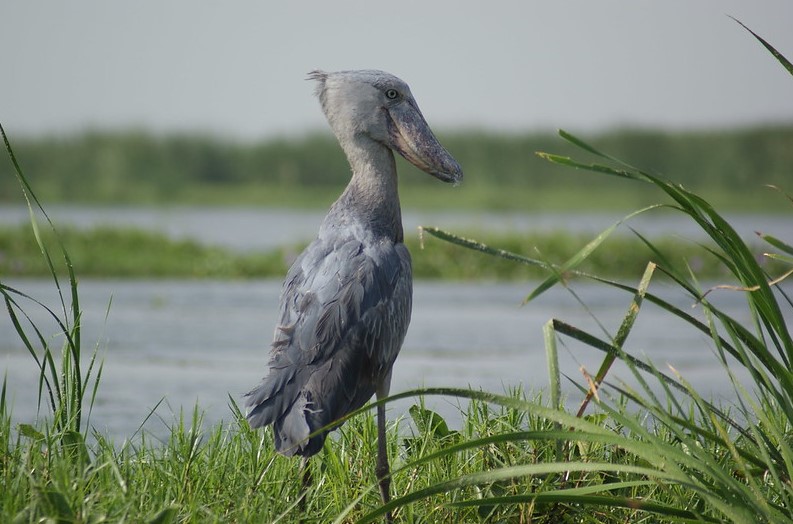
Shoebill stork at Lake Albert. Photo credit: Per Holman
Sio-Siteko Wetland landscape is located northeast of Lake Victoria and encompasses the lower catchment of River Sio in Kenya and cutting across to Uganda. It consists of several interconnected secondary and tertiary wetland systems lying between latitude 0.47 – 0.21 ° N and longitude 33.98 – 34.20 ° E with an approximate area of 415 square kilometers .
In the dry season, flooding is limited to the stream channels However, during and after the long rains between March and May, the wide floodplains of River Sio and its tributaries are submerged. Administratively, the Wetland is located in six sub-counties (Buhehe, Busia TC, Dabani, Lumino, Majanji and Masinya) covering an area of 182 square kilometers in Busia District of Uganda, and four sub-counties (Butula, Funyula, Matayos and Nambale) of 233 square kilometers in Busia County in Kenya (NBI, 2020). Sio-Siteko is a complex ecosystem with different unique habitats supporting a wide range of biodiversity and the communities and their livelihoods in and around the wetland.
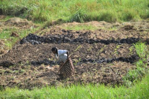
Subsistence agriculture is one of the main livelihood for communities living around the transboundary wetlands
This project is implemented in collaboration with Acacia Water, Nature Uganda, Nile Basin Initiative (NBI) / Nile Equatorial Subsidiary Action Program (NELSAP) with support from Deutsche Gesellschaft für Internationale Zusammenarbeit (GIZ) GmbH, on behalf of the German Federal Ministry for the Environment, Nature Conservation and Nuclear Safety (BMU) under its International Climate Initiative (IKI).