
In the heart of Ethiopia’s Oromia region, some 200 kilometres south of Addis Ababa, lies a breathtaking landscape, home to the Abijata-Shalla Lakes National Park. This pristine but fragile sanctuary encompasses the Abijata and Shalla lakes, and is both a haven for unique biodiversity and a testament to the remarkable restoration efforts taking place in the region.
Abijata and Shalla are two inter-connected lakes in a semi-arid landscape, each offering distinct characteristics and ecological wonders. Abijata, with its saline waters, attracts thousands of flamingos (both lesser and greater) from Kenya and Tanzania, pelicans, and other water birds, creating a vibrant spectacle of colours against shimmering blue waters. With a depth of up to 14 metres, this lake acts as a crucial feeding ground for the avian visitors, some of which, like the shoveler and black-winged stilt, seasonally flee the wintery climes in Europe and Asia by the thousands from, making these waters an ornithological paradise.
Located in the crater of an extinct volcano, and to the south of Abijata, is Shalla, Ethiopia’s deepest lake at 266 metres. Shalla, too, is saline and has hot springs, a mesmerizing waterfall and several islands where birds like cormorants, storks and pelicans breed. Its surrounding forested areas harbour diverse wildlife such as greater kudu, aardvark, jackal, bat-eared fox, Grant’s gazelle, warthogs and monkeys. When the great white pelicans move between the two lakes, it’s a sight to behold and a sound to remember!
Human impact on fragile landscape
Together with freshwater Lake Ziway, the saline reddish-brown waters of Lake Langano and the tiny tropical crater soda lake Chitu, these five central Rift Valley lakes and their surrounding areas form a closed basin that provides water for 3.3 million inhabitants and supports a diverse range of plant and animal species in addition to cultural and spiritual significance for neighbouring communities.

The massive gully that has carried tonnes of soils from the watershed toward Lake Abijata
To get to the watershed, one must drive off-road from the main highway for 25 kilometres. The rocky road has seen better days and, in some sections, has been severely chipped away by the rainwaters gushing down an adjacent massive gully. A few gabions have been installed on the severely eroded sections, but still, this is not enough. The three and half kilometres long gully originates from the higher grounds of the Park and snakes its way to the human inhabited areas.
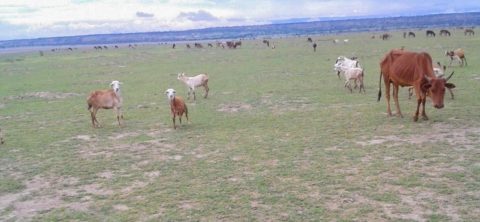
Livestock grazing on the dried up grounds of Lake Abijata following degradation in the watershed. Abijata in the far background
The local community rears livestock and farm crops for subsistence. In the past, they lived outside the Park’s boundary but with a growing population, encroachment into the protected area was inevitable.
Over the years, the Abijata-Shalla Lakes National Park faced severe environmental challenges. Increased human activity, unsustainable farming practices, pollution and the vagaries of climate change began taking a toll on the fragile ecosystem. River Bulbula from Lake Ziway used to feed Abijata. But high water abstraction to allow smallholder farmers and multinational companies irrigate their farms reduced the freshwaters draining into Abijata. Over time, these threats disrupted the delicate balance, leading to habitat degradation, water pollution and declining biodiversity.
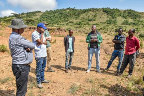
Wake Tuke, Acting Park Warden (in green jacket) briefs Ayele Kebede of Sida (far left) and Wetlands International team during a monitoring mission of the watershed rehabilitation works
Wake Tuke is the acting Park Warden and Head of Finance for Abijata-Shalla Lakes National Park. Born and bred in the area that he currently serves, he has seen the degradation firsthand. “When I was growing up, this area was forested. Then encroachment into the Park began and, at some point, it was on the verge of closure due to illegal activities. The landscape was stripped bare after trees were cleared for charcoal and wood fuel. Conflict between the community and Park management escalated. Around 2015, Lake Abijata’s size was only 132 square kilometres, having receded from 198 square kilometres in early 1970s. The situation was dismal,” he explains.
Teshita Mohammed of Fike Nature Conservation Association agrees.
“We saw the shrinking of Lake Abijata and were shocked by an awful stench that emitted from the lake. We were informed that it was due to the severe landscape degradation and that spurred our community into action.”
Collaborative and Multi-disciplinary Approach
With support from Sida together with the Netherlands Enterprise Agency (RVO), Swiss Agency for Development and Cooperation, Netherlands Government for Projects of SaWeL, Sustainable Water Fund and WASH-SDG, Wetlands International is spearheading a multi-stakeholder and multi-disciplinary approach to save the Park and restore the larger landscape of the Ziway-Shalla basin.
“The Government had limited capacity to support both the community and restore the environment. It’s through the support of Wetlands International that this area is now transforming, which is a boon for the Park’s ecosystem. The area is being reclaimed from the vagaries of encroachment, while still engaging the local community through formation of CBOs to undertake restoration measures,” says Tuke.
Development of eyebrow structures to reduce soil erosion and harvest rain water
Mustefa Haji Tahir, a community elder in the area, stresses that his community has put in great effort despite numerous challenges. “This area was bare when we started the rehabilitation works. We were advised that it could transform by using watershed principles and stopping the cutting of trees. Today, the erosion and siltation are reducing, and we have seen some remarkable changes. We are now getting better rains than we did in the recent past, an indication that the rehabilitation of the landscape is successful.”
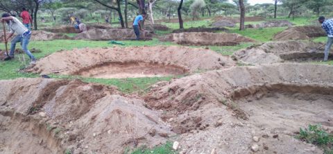
Ongoing rehabilitation works this year to reinforce soil and water conservation structures by Fike Nature Conservation Association
Ashu Bade, who is chairman of Fike Nature Conservation Association CBO that is working on the adjacent area to Mekane Fike group, says the area they have started rehabilitating was denuded.
“We used to bring our cattle and goats here to graze. That pressure on vegetation and soil resources led to degradation. Then we saw what our neighbours doing and that inspired us to form our own group and getting working as well. We have 214 members (118 males and 96 female) working to restore 270 hectares. We are planning to connect our work with that of our neighbours to curb erosion in this whole landscape and allow for regeneration of the environment,” he states.
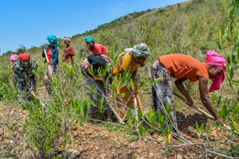
As part of the restoration efforts, 76,928 water and moisture harvesting structures have been used to reduce runoff and curb erosion and siltation into Lake Abijata. These comprise eyebrow and half-moon basins, deep trenches, terraces and improved pits that are erected based on the terrain and site-specific issues. In addition, about 31,159 metres of soil and curved stone bunds have been built. In some areas, there are bunds and terraces only, and in others a combination of structures.
“We had gullies everywhere. The soil was heavily eroded, the ground exposed with no vegetation cover. We are working alongside the men and the work is tough. But we are persevering since we have seen the area get transformed before our eyes. We benefit equally, both men and women,” states Medina Bedaso, one of the 96 female members of Fike Nature Conservation Association CBO.
Beacon of hope
Restoration of 3301 hectares is ongoing with direct support to 15,799 community members (male 11,529, female 4,270) who were equipped with 4,418 tools. Wetlands International also helped to develop a monitoring plan for these restoration works, and which was submitted to the Government. The plan is used to physically monitor progress on the ground every quarter by a multi-stakeholder platform.
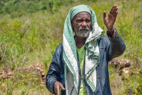
Mustefa Haji Tahir at the watershed area which has seen tremendous regeneration after soil and water conservation measures were installed to restore the area
Elder Tahir has his sights on the infrastructure. His concern is the economic growth for his people. “The road from the main highway to the Park’s watershed is dilapidated. This hill is our mountain, our watershed, and offers great views of the lakes Abijata, Shalla and Langano. It is ideal for ecotourism from which our community could benefit. But only if the road is more accessible,” he states.
As recent as 2021, scholars had forecasted the imminent doom of Lake Abijata given its high receding rate. But with the major watershed rehabilitation intervention and better rains, the stench is gone and the lake is almost back to its 1970s form. More birdlife particularly flamingos and pelicans are flocking these lakes and about 200 greater kudu have been sighted in the Park, up from 50 individuals in 2018.
With their awe-inspiring beauty, and ecological and economic significance, these central Rift Valley lakes today serve as a beacon of hope for landscape restoration.
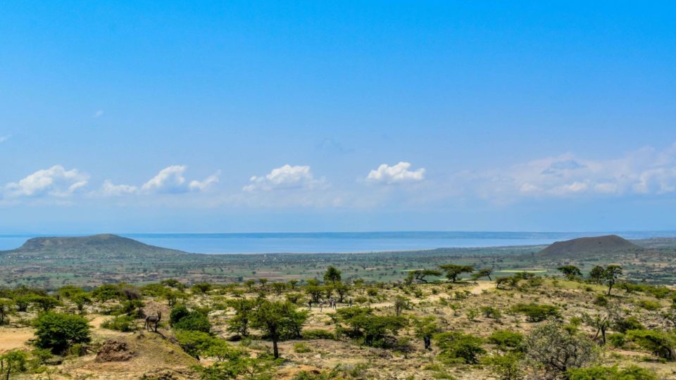
Lead image: Regeneration of vegetation cover in the Abijata-Shalla landscape. Lake Abijata in the background
Leave a comment